India's Kalindi Khal Expedition
by Upasana Ray
In August 2017, a bunch of enthusiastic mountain lovers including myself were all set to start an expedition in Uttaranchal which is supposedly one of the toughest in India, especially amongst the Garhwal Himalayas. We were unfortunate as we got to know just the day before our flight that due to a major landslide and bad weather in Gangotri, the route from Gangotri to Nandanvan was affected. Hence the expedition stood canceled. The journey that I am talking about here is the Kalindi Khal expedition.
This expedition starts from Gangotri and ends in Badrinath. The mountain range over here gifts us with close up eye contact with some of the Himalayan giants like Mt. Shivling, Mt. Bhagirathi (I, II and III), Kedar dome, Mt. Satopanth, Mt. Vasuki and Chandra peak. The treacherous terrain will also let you witness some of the gigantic glaciers like Gangotri glacier, Chaturangi glacier, Shweta glacier and Kalindi glacier. The journey is tough but tough gets going. The weather is uncertain but the uncertainty also gets going and at one point you will feel that your body is aching but still you are getting soaked into the uncertain, dangerous yet rewarding adventure.
In September this year again, another group of 4 dare devils were planning to go for this trek. I could not ignore my heart and decided to join them. Rush, rush, rush.......I spoke with our guide Mr. Vinod Panwar and Mr. Chandan Singh Bisht of the trek agency and requested them to consider me even if it was a last minute request. They were kind enough and my permits and insurance were arranged. I was ready to go. So, the team was now final and we were five: Saurav (the gang leader/ coordinator), Sundeep (he was already in Uttarkashi area for almost a month with his father who was supposed to join us), Jhankar, Tarun and myself. Jhankar, Tarun and I graduated from the same college; hence, I was excited to have some known faces with me (how we know each other is another story.........).
On 8th of September, I was on my flight to Delhi to meet the group (except Sundeep) at New Delhi railway station from where we all were boarding the Nanda Devi express till Haridwar. Thus, four of us reached Haridwar on 9th September early morning. After chatting for sometime, we were quickly on our bus journey now from Haridwar bus terminus to Gangotri, a day long travel with in between breaks. This bus journey led us to Gangotri late in the evening
10th September was a rest day at Gangotri. So, we took it easy and did some local sightseeing, easy meals and some snack shopping for the trek. For the first time in my life I learned how to play cards from the 'card-guru' Tarun. Believe me, then onward I started winning many of the games that we played during the trek, although a first timer for card games. Our trek had to start from the 11th. We met our guide and porters in the morning of the 11th, had our breakfast and set afoot on the trail. Thus, the expedition started.
The trek route TO BE followed was as follows (altitudes are approximate):
1. Gangotri (~3048m) to Chirbasa (~3600m)
2. Chirbasa to Bhojwasa (~3792m)
3. Bhojwasa to Nandanvan (~4500m)
4. Nandanvan to Vasuki Taal (~5300m)
5. Vasuki Taal to Khada Paththar (~5456m)
6. Khada Paththar to Shweta Bamak (Glacier) (`5500m)
7. Shweta Bamak to Kalindi base (~5590m)
8. Kalindi khal (Kalindi pass crossing ~6000m) to reach Raj Parav (~4900m)
9. Raj Parav to Arwa Tal (~4500m) (This camp was skipped to save time. We trekked from Raj Parav to Ghastoli)
10. Arwa Tal to Ghastoli (~3600m)
11. Ghastoli to Bandrinath via Mana (~3400m)
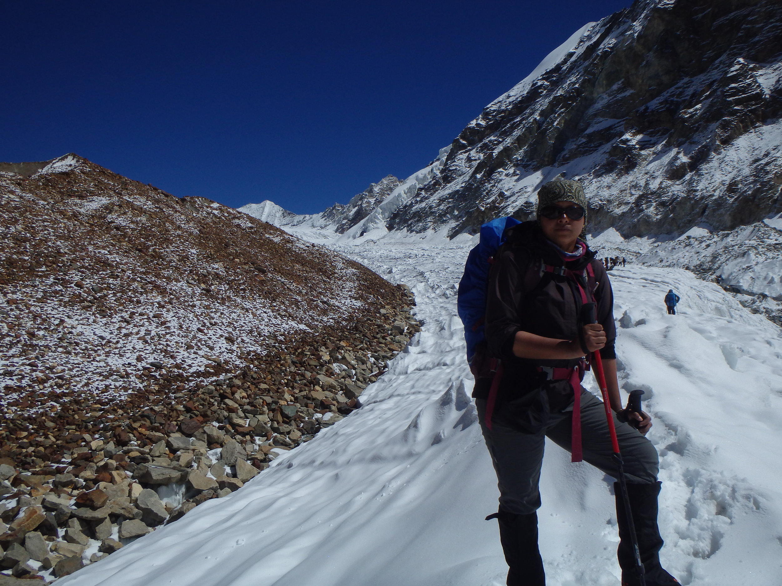
The weather was clear and sunny, very impressive. The trail was dusty to begin with. Mule dung scattered on the way. Slowly the narrow trail led us to a check point with a big gate welcoming us to the Gangotri National Park. After all the necessary document check, we were allowed to proceed. Our destination on this day was till Chirbasa where we reached by afternoon. The camp was set. I felt later that one might just keep walking and continue onward to Bhojwasa as the altitude till this point does nor vary to an extreme. Up to you though!
On the 12th, we were in no rush. The trek for the day was not hard. We had our breakfast and by around 8:30am in the morning, we started walking. Before this day I hardly spoke to Tarun and Jhankar. In our college days we knew each other mainly by face. The trek to Bhojwasa let us talk more. A bee on the bush towards mountain side! Tarun had a DSLR and desperately wanted a good click. The bee waited for long. Tarun was not ready yet. He took out his camera but oh no! He was loading his battery and then his SD card. The camera was now ready. Alas! The bee had gone. I said, "not bee's fault, never-mind, will get another."
We moved on. On the way to Bhojwasa, there was a stream that needed to be crossed via a small bridge. As Tarun and I were crossing the bridge, Jhankar, who had already crossed, asked us to wait for a photograph. Tarun started getting ready for a nice pose. Suddenly, I saw something falling down off his head into the gushing, roaring water below us. It's his sunglass! By the time he realized, it was flowing in Bhagirathi. His grade 4 (according to him) mountaineering sunglass! Gone. We consoled Tarun and gave him some time to even 'search' his lost property. Of course he could not find it as by now it would have already reached Haridwar!
Then we started again. We were not left with a lot of distance now. Slowly, we reached Bhojwasa. At Bhojwasa, many Himalayan 'sadhus'/ monks also stay. Some people were busy listening to one such 'baba'. Here, in Bhojwasa, Sundeep joined the group. His father would return towards Gangotri and we will proceed further towards Nandanvan, our next camp site. Apart from us, there were couple of other groups as well on Bhojwasa camp site although they were not trekking till Nandanvan.

Gaumukh
On the 13th, we were trekking under a clear sky and open landscape of high peaks and roaring river on our right towards Nandanvan. Here, Ganga is also alternatively called as Bhagirathi. It is believed that Bhagirath, the ancient king brought Ganga down from heaven. Thus, the name Bhagirathi. Ganga (Bhagirathi) originates from Gangotri glacier at Gaumukh. Later at Devprayag, the name Ganga appears when Bhagirathi meets Alaknanda. That's a bit of Hindu mythology. So, we were following Bhagirathi down on right side of the cliff and proceeding essentially towards Gaumukh. At Gaumukh one can see Mt. Shivling and the three peaks of Mt. Bhagirathi.

Gaumukh with Bhagirathi peaks visible at the back
We took a break at Gaumukh as the terrain was rough today with rockfall and landslide areas at many places. We managed to click some photographs as well at Gaumukh. My mom had asked me to get a stone from Gangotri area, so, I picked up one at Gaumukh. Ready to roll again. Further ahead of us was a difficult route. We had to cross the Gangotri glacier, the rockfall and moraine with huge crevasses all over, carefully reaching at the base of a steep long climb towards Nandanvan. On our way earlier, we met two injured men. One had a leg injury. He was returning back. The other man had a bleeding finger. He got hurt from a rock that fell off the rockfall zone near Nandanvan. We paved our way extremely carefully, with all our limbs secured firmly. We were getting tired. We climbed foot by foot, took break when required until we finally reach a wide open land surrounded with Mt. Shivling, Bhagirathi and Kedar dome peaks. We reached Nandanvan. Huff!
Although it was sunny, due to wind I was feeling chilly by the evening. Saurav and Traun did some milky way photography that night as the sky here was so clear and starry. Heavenly!
Shivling on my shoulders! I was waiting for a sunrise moment. I woke up very early the next day, probably by 4am and kept checking every 15-20 min if the sun is rising. Finally, I shouted,'sunrise','wake up'! A tiny part of the Kedar dome and then Mt. Shivling had started showing morning colours. Click, click, click!

Mt. Shivling
Last night Jhankar had an issue with his digestion, so, I had given my medicines to him. Strangely, I also started feeling discomfort in my stomach. Could be the water. One tablet.....be safe! Jhankar although considered the cashews that we ate last night to be the culprit! I avoided the chashews for rest of the trek.

Kedar dome
The 14th of September was the day to trek to Vasuki taal. Everyone started the day's journey. I was feeling a bit sick in my stomach. I asked Tarun to be with me just in case I need anything! He was very supportive and kept moving with me. Whatever I was feeling, the scenic beauty was so tremendous that I kept myself diverted towards it.The Chaturangi glacier was on our left. Chaturangi glacier is made of three tributary glaciers (the Seeta, Suralaya and Vasuki) and gets its name due to the four colours of this glacier (red, black, white and yellow).
After a walk on the moraine for sometime, there was a steep descent over loose rocks and scree followed by a steep ascent. Towards the last part of the long climb I found rope fixed up. We climbed up. As we stood up we could see Vasuki taal and some tiny yellow tents

Chaturangi glacier

Mt. Satopanth
After reaching campsite, I wanted some rest so I went for my tent. Others managed a visit to the army tent where they were told that the weather might be bad on the 17th. So, we were advised to cross Kalindi pass sooner. Originally Vinod ji (our guide) was advising us to get our first rest day here at Vasuki Taal as after this we will be staying mostly on glacier and resting there won't be pleasant. However, after the weather prediction, he changed his mind and suggested that we proceed.
So, no day off. On the 15th, we packed up and left Vasuki Taal towards our next point, Khada paththar. Enroute to Khada paththar, we saw huge glacial openings and crevasses, some were dry, others were like ponds but frozen on the top. Icycles hang on the rim of such formations. We also witnessed Mt. Satopanth on our right.

Glacial water
After huffs and puffs, ups and down, one final ascent led us to khada paththar, a rocky area to camp on. We reached got there early. So, we had a long day to spend here and rest. After this, we had to live on snow and ice only for three days as the camps would be on glacier. So, although rocky, this was the last better camping area. Weather was good and not so windy. So, we could enjoy the afternoon outside our tents. We had not taken any day off. So, in the back of our minds, we were thinking if we could take one rest day here as spending extra day on icy glaciers won't be possible. This was the last ice-free camp zone.
We were in our tents trying to get good sleep. We heard some sound.......may be its wind. The early morning of the next day (the 16th), we learned that it was snowing hard. The prediction was a bad weather after the 17th. Vinod ji informed that we can't move higher in such a weather. So, we were taking a day off. If the weather clears off next day we could start. As we need to traverse Shweta glacier after this point, it would have been dangerous to walk in bad weather. The glacier at that part is full of crevasses. Additionally, camping on a glacier in bad weather would be a silly decision. So, we stayed back curdled in our sleeping bags. I was happy that we were having a rest day, I wanted it.
Next day, we had to start. But, to our surprise, the weather did not improve, It was snowing for almost 24 hours and windy as well. Cloud was getting settled over Khada paththar area and there was a white out. We knew, we can't move today as well. The 17th was also gone. We lost both of our buffer days. Vinod ji said, if this continues, we might have to turn back. We were also using up our ration. Turning back was also not an easy task in this weather. We had to face Shweta glacier and the dangerous Kalindi pass itself if we move on, or, tackle Gangotri glacier if we turn back. Since, turning back would at least avoid altitude gain, it was decided that on 18th, if the weather does not settle, we were going back latest by 19th. We all were depressed and frustrated. We were stuck in such a situation for 2 nights now. It was a second trip for me. I was expressionless. I just prayed for the weather to get back.

Weather turned bad
On 18th early morning, we could not see a clear sky yet. The expedition was over for us. However, after a while the blue sky started showing up. We saw Vinod ji, some porters and Saurav discussing something standing on a cliff facing towards the point where Shweta glacier should be visible. Pack up, move.......we are moving on.......said Vinod ji!
Unbelievable! Everyone jumped out of the tents and within minutes were ready to move. So, on the 18th, we were trekking towards Shweta glacier and we were supposed to walk as much as we could stretch. The decision was that in case the weather turns its back again, now since we are on a glacier of this nature, our direction of move will depend on whether we are more towards Khada Paththar or Kalindi Khal.

Glacier walk

Icy water filled crevasse of Shweta glacier
The descend from Khada Paththar into Shweta glacier was extremely steep, almost vertical and tricky. If someone falls, he would tumble straight vertical down. After this part it was a tiring glacier traverse till we decided to camp for the night. What a relief! Although the terrain was hard, the mesmerizing views of this expedition would keep your spirit high. At this camp site, we could hear loud noises (avalanche) throughout the night. Probably, ice chunks or rocks from the nearby peaks falling into the glacier was making such thunder-like sound. What an experience! In fact, Vinod ji said that while sleeping if you remove your cap from your ears and keep your ear on the tent floor, you can hear the glacial water flowing. However, it was so cold and I was so tired that I did not attempt to hear the underground.........I tried to sleep.
The 19th of September: After a porridge breakfast, we all got ready for Kalindi base camp. It was shivering cold at Shweta glacier camp that day early morning. Slowly the temperature became a little warmer after the sun got brighter. Ah, finally, absolutely clear blue sky with no sign of cloud at any corner. We were definitely heading towards Kalindi base camp. This day we experienced heavy snow, glacial ice, crevasse crossing, yet mind set for breaking all road blocks. At times I found huge snow piles on the glacier of almost my height or at least till my chest. The route was full of snow/ice-wave-like structures..........amazing!

Traversing Shweta glacier
Finally, we reached Kalindi base camp after crossing a final huge but beautiful section of Shweta glacier. The base camp is situated near the confluence of Kalindi and Shweta glacier. So, when standing on the base camp, on one side you would see Kalindi glacier and on the other side, Shweta glacier. The pass was visible from this place. In front of us, the gigantic Avalanche peak was staring at us. However, we were safe as any avalanche from this peak would fall into the Kalindi glacier and we were on a high raised glacial moraine. I had requested for a toilet tent. In the base camp, the only place where it could be placed was the slope towards the Kalindi glacier. So, essentially, it was a hanging toilet. If you slide down, you will fall in the glacier with no time to pull over. Anyways, that did not happen.

Icy crevasse
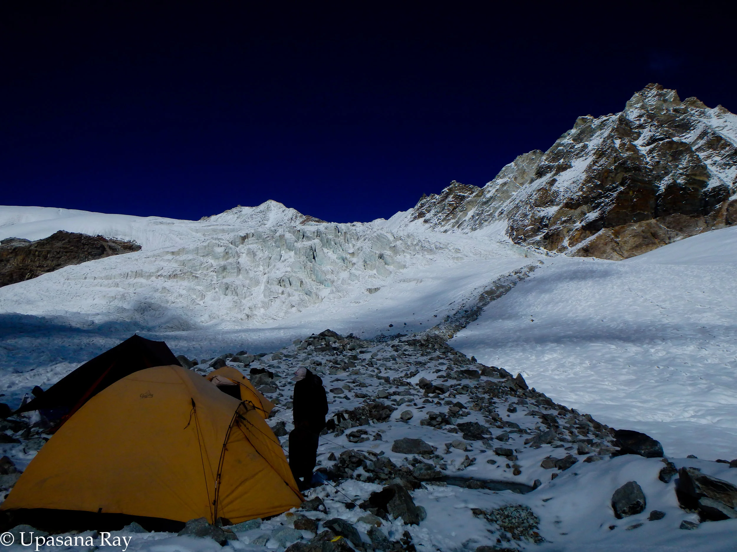
Kalindi base camp

A view from Kalindi base camp
Due to the glacial walk and sweat, our shoes got wet partially and we had kept our shoes for drying under the sun. Jhankar wanted to shoot a video and called us outside on a spot. I was in my camp shoe, so, to avoid cold exposure remained in my rent. Jhankar and Tarun had a good time. But, accidentally, Jhankar slightly slipped into glacial water. Although it was only his feet, the bone cracking cold water almost froze his toe. He came back and changed socks, wore down booties and slowly managed to get rid of that pain. On the other hand I was really surprised to see the oldest porter of our team to wash his feet in glacial water. Uff! Jhankar gave one pair of socks to him. We had an early dinner as it was sub zero temperature and we had to start pass crossing very early morning next day.
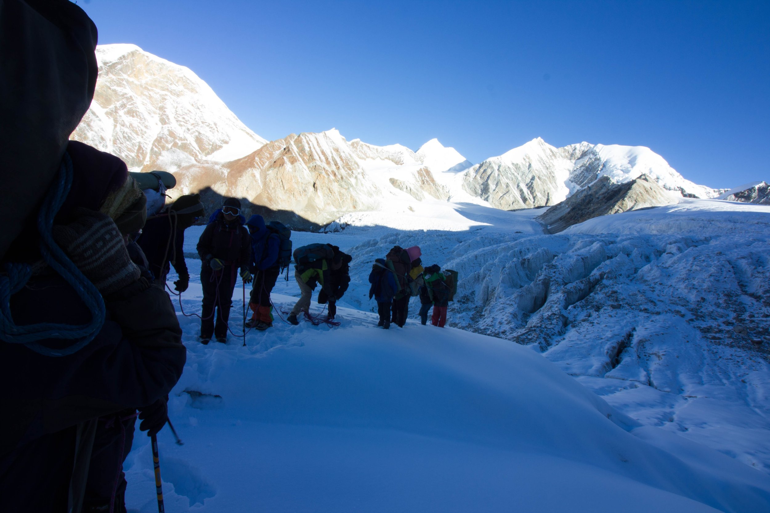
The team getting roped up (Photo credit: Kumar Saurav)

Approaching Kalindi top (Photo credit: Kumar Saurav)
We were asked to vacate tents by 4am on the 20th. We were walking by 5 am. The pass was heavily loaded with snow. Vinod ji was leading to open the route. Huge, deep crevasses were all over. After half way careful climb, we had to get roped up to avoid falling in crevasses. We were approaching 6000m, hence we could feel the scarcity of oxygen. Added to the difficulty was freezing temperature. The sun had now started showing up. My fingers were freezing. After the major crevasse zone, we were released off the rope. I could feel my breath. My hands! I told Vinod ji that my fingers are freezing. Couple of times he removed my gloves and massaged my hands (in this area frost bite is very common). I kept moving my paining fingers to allow blood circulation. While all these were happening, my legs were moving towards the pass top slowly. After a long climb finally I could feel the first effective heat from the morning sun. Simultaneously, I found that I could hear others at the pass top and then I could see the top. I was on Kalindi top. Its done. Now, it was a quick camera time. Our guide and porters performed a traditional 'puja'/ ritual at the pass top near the national flag that was placed there. We all participated.

Vinod ji performing local ritual at Kalindi top

Group at Kalindi khal top

A panorama from Kalindi top
At times I was slipping in the deep snow but re positioning again. I saw Jhankar sitting on the way down. He drank some unclean water earlier due to which he was not feeling well. He wanted clean water. But, I could not help as instead of water I had oral re hydration solution. Someone else in the group could give Jhankar water. He was fine later. So, water 'quality' is important!

The initial part of descend from Kalindi top
Now, we all were at a very steep section of our descent. We took it slow but stable. At one place I saw blood on the snow. Someone had cut his finger while descending. On one section we used rope to climb down a vertical rock wall. One of the porters was belaying at the bottom.

Then again a steep walk down and we reached a snow/ice field. We still had a very long way to cover. So, after few minutes rest we started crossing this snow field. Now the sun was bright and in spite of heavy snow cover, I was feeling hot while walking. It was not windy here. It was like a snow desert with some crevasses and associated ice covered streams.

Crossing a snowfield
After a long walk on this snowfield with couple of breaks we slowly approached a comparatively snow free zone where we had our packed lunch. As it was a long day, after lunch it was very hard to get up and continue walking. Legs were paining. Lactic acid! Lactic acid, so what? For us its not the lactic acid that dominates.......it's the adrenaline rush that drives! So, man, we all got up as we had to reach Raj Parav which was now couple of hours away. Now, that the snow was almost gone, we were walking over rocks and boulders.
We reached Raj Parav. it was a wide open area on the bank of a stream surrounded by cliffs and peaks 360 degrees. After freshening up we had tea and biscuits and sat on a rock to chat with each other. Our guide, cook and porters also joined the conversation. We were happy that we could successfully cross Kalindi khal. Now, we were discussing how uncertain it was couple of days back. This part of the trek had strong sunshine. After the day long snow walk, our shoes were damp. We kept shoes for drying. Nice and warm. We were feeling so happy. However, since we lost our buffer days, we decided not to stay at out next day's camp site, Arwa taal. Instead, we were skipping Arwa taal and directly reaching Ghastoli, the final camp site. So, the next day was also supposed to be a long day with stream crossings.

Camp at Raj Parav

Arwa taal
On the 21st we started our last long day. We were expecting to get army vehicle from Ghastoli check point till Badrinath for 22nd. If not, we had to walk till Badrinath. The trek from Raj Parav to Ghastoli was very scenic with snow peaks visible throughout and wide valley with mountain stream gushing enroute. We were following this stream/ 'nala'. Arwa taal (nala or river) is less swelled up in the morning time and thus easier to cross. In the monsoon season the water level rises high. We got lucky. We could get away with it by just removing our shoes and crossing the river. Some people tried superhuman jumps! Whatever, the method was, we all crossed the river and followed the river towards Ghastoli. Last couple of days we were so lucky to have a clear weather. Now, while walking towards Ghastoli, we could see dark cloud formations on the mountain peaks. Slowly, the weather looked turning bad again. However, now we were close to Ghastoli. So, we were out of danger. Plus, our trek was almost over.
At some distance across the valley, now we could see the army check post of Ghastoli. We felt close to civilization after a long time. Happy at heart, I felt as if I got an extra ounce of energy pumped into my legs. We were soon at Ghastoli.

Bad weather was back
The tents were put up. After sometime one army personnel came for checking. We had to move towards road head for the vehicle by 7am.
Next day we all reached the road head on time. Vinod ji went to the check post with our documents and for inquiring about any possibility of a vehicle.
But the weather was so bad that army vehicle refused to start. So, disheartened, we started on foot for Badrinath. After couple of hours of walking, to our relief we got a truck. The truck was going till Mana check point. Truck journey was painful but faster.

The moment: Saurav, Tarun and Jhankar displaying an overflow of excitement upon reaching civilization
It was raining as well. We ultimately reached Mana. From here, we walked till Badrinath to our guest house. First thing first! A long hot shower was a must to wash off days old dirt and sweat! Ah, so fresh!
Here, in Badrinath we enjoyed nice meal after so many days and visited Badrinath temple in the evening. It was raining in Badrinath.

Badrinath temple
After our dinner we checked with the bus depot for next day's (23rd) bus towards Rishikesh. There were three options: 3:30am, 7:00am and 8:00am. Saurav, Vinod ji and porters decided to board the 3:30am bus. Initially I opted the same. However, later changed my mind to board a morning bus with Tarun and Jhankar. Sundeep was not coming with us as he had another trek lined up. He was staying back at Badrinath. After saying good bye to our guide and porters, Tarun, Jhankar and I slept. I was targeting 7:00am bus, I could guess that my other two friends are not willing to. Later I realized that even I I was not willing to. Then, at 7:30am we got ready and ran to bus depot for the 8:00 am bus. The bus was full. So, next option was to go to Joshimath and get a bus. Since there was no other alternative, we first had a Maggie breakfast. Then we found that because of many Rishikesh travelers in the bus depot, one of the Joshimath buses changed it's route and now we had a bus till Rishikesh! Yayyyyy! So, we were on our way to Rishikesh. To our surprise, later in the day we heard back from Saurav that due to landslide, his bus was stuck for 2 hours at Srinagar. At that time we were just around 30 min away from Srinagar. So, we were going to reach Rishikesh almost together.
It was approximately 9pm when we reached Rishikesh bus depot. Saurav had already reached and checked in to a nearby hotel. We also went the same place and booked rooms. After dinner in the hotel we slept. Next day we wanted to do some sight seeing in the nearby areas. We mainly went to Ram Jhula and surrounding areas. The day went easy and next day (25th) was our flight back to home.
Overall, it was a great experience. I got lost in nature and mountain madness. Made new friends. For initial few days I was recovering from the exhaustion but now I am planning again for the next Himalayan exploration...........for now we are planning Bhagirathi II climb. Back in civilization........I am not liking...............I want to go back.......I want to smell the mountain air, get tired, have blisters on my foot, scratches on my skin and get snow burnt face.